Kakadu Road-trip by EV: sensing grandeur, navigating limits

Kakadu National Park is vast – any way you think about it. Located at the Top End, it is Australia’s largest terrestrial national park and home to a whopping 30% of Australian bird life.

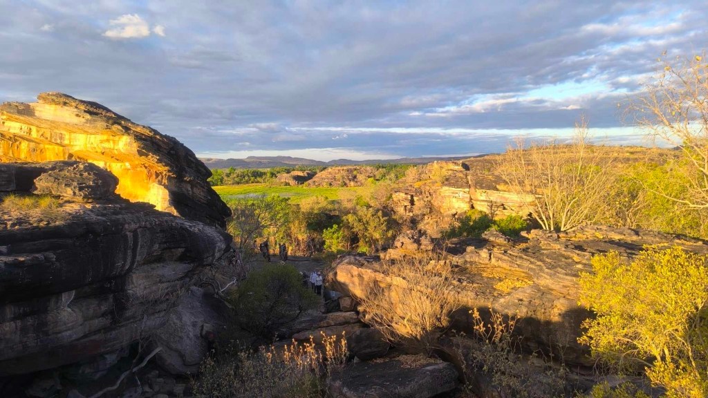
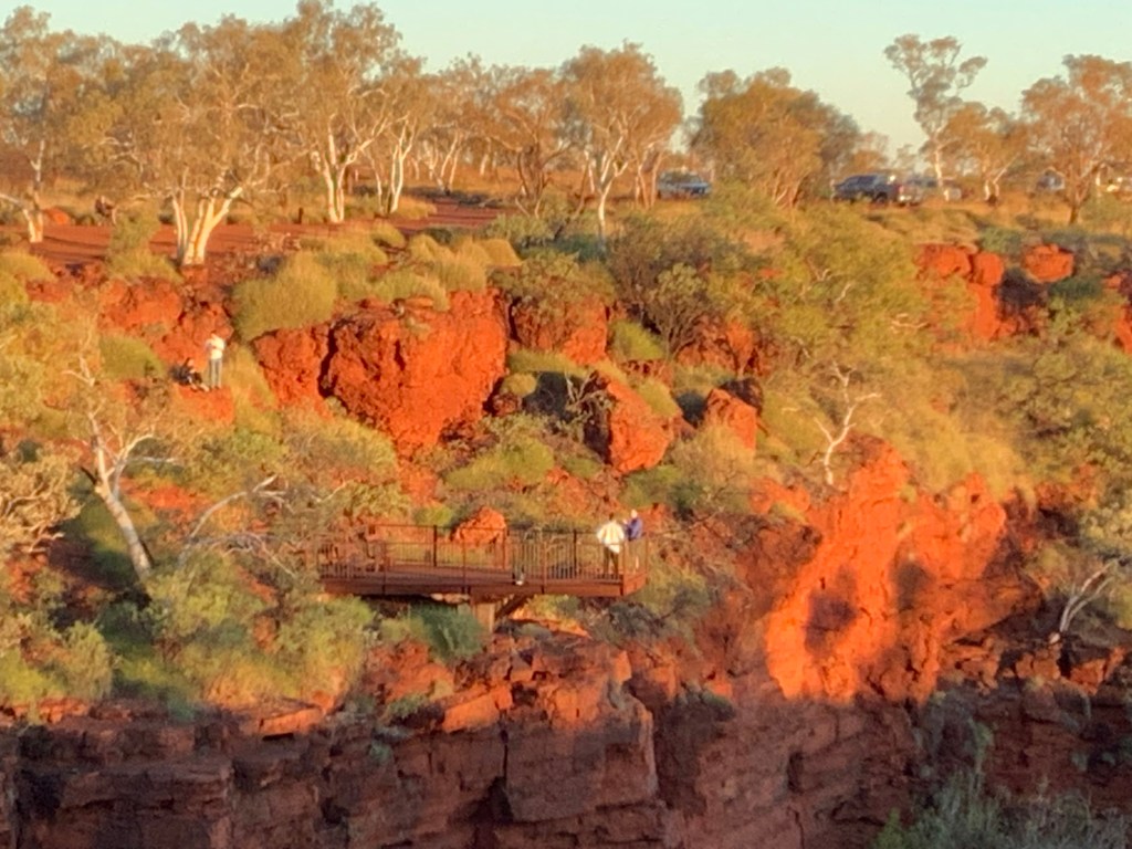
Something of the grandeur and gravitas of this place begins to make sense when James, a young Bininj man, budding lawyer and Park Ranger, guiding us around the rock art at Burrungkuy, relates a conversation with his uncle, who is one of the traditional owners of this part of Kakadu.

James to his uncle: ‘some people say there have been humans here 60,000 years. What do you think’. Uncle says: ‘Our ancestors have been here for ever!’ 60,000, infinity, what’s the difference, anyway? James concludes.

Iconic but not necessarily ancient, Anbangang rock art gallery, Burrungkuy

Kakadu is one of just four places in Australia (and just 38 in the world) that the United Nations lists as ‘world heritage site’ under both natural and cultural categories.

We are here in the last week of August, when Wurrkeng (the coolest season) is giving way to the start Kurrung – in mainstream ‘Aussie’, it’s almost spring. About 200,000 tourists visit Kakadu each year – not a great number considering the vastness of the park – nearly 20,000 sq kms. So, even in high tourist season, even on the main road that takes you into Jabiru township, from the gates of the park and back out to Highway 1 at Pine Creek – a total drive of 230 kms+ – you are likely to see more animals than cars, especially in the early morning, including some non-natives, like feral pigs, but plenty of natives too and birds who might just be passing through.

Birds at dawn, Mamaluka Wetlands

Getting to the sublime via the ridiculous

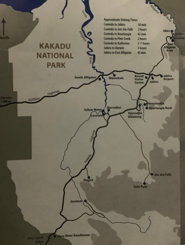
Kakadu might feel remote. But it is just 150 Kms from Darwin to the gates of the national park. And another 100 kms or so will bring you to the little settlement of Jabiru with various accommodation options, or Cooinda with slightly more expensive options.

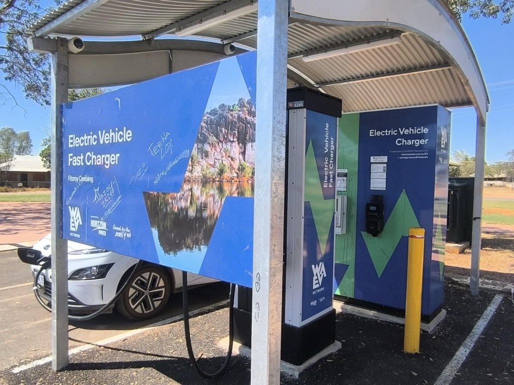
Darwin has excellent fast chargers. Just south-east of Darwin, Palmerston is your last fast charger until you get back to Katherine. This means minimally 540 kms, plus the driving inside Kakadu park. All this calculation is bringing on an attack of range anxiety for Co-Pilot – so we stop to top up at Palmerston. Unnecessary.

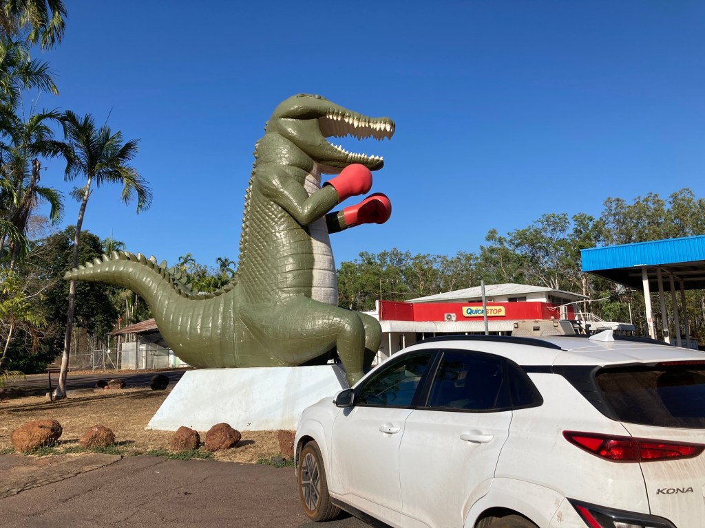
And talking about the ridiculous, at Humpty Doo, you cannot miss the world’s only boxing crocodile.

Humpty Doo petrol station, just as useful to us as its boxing croc

There are AC chargers available both at Jabiru and Cooinda. So there is no real cause for range or charger anxiety. You can charge your car overnight if you are happy to pay for a powered caravan site or you can charge on a 3 phase plug at an hourly rate of $10 at Aurora Kakadu Lodge.

Where in Kakadu

Unless you spend your lifetime here, or fly over it for a bird’s eye view, you are never going to see most of Kakadu. Criss-crossed with rivers and marshes, much of the park is not passable by any terrestrial vehicle most of us would drive.

We decided, even before setting off from Perth, to put some limits on this road trip. We go only where the road can take us – and that too is limited by the capacities of a 2 wheel drive.

But our stars are in alignment in Kakadu. Just in the two-and-half days we have here, Co-Pilot finds three marvellous tours with indigenous guides, of rock art sites and a crocodile habitat.

Crocodiles at Cahill’s Crossing

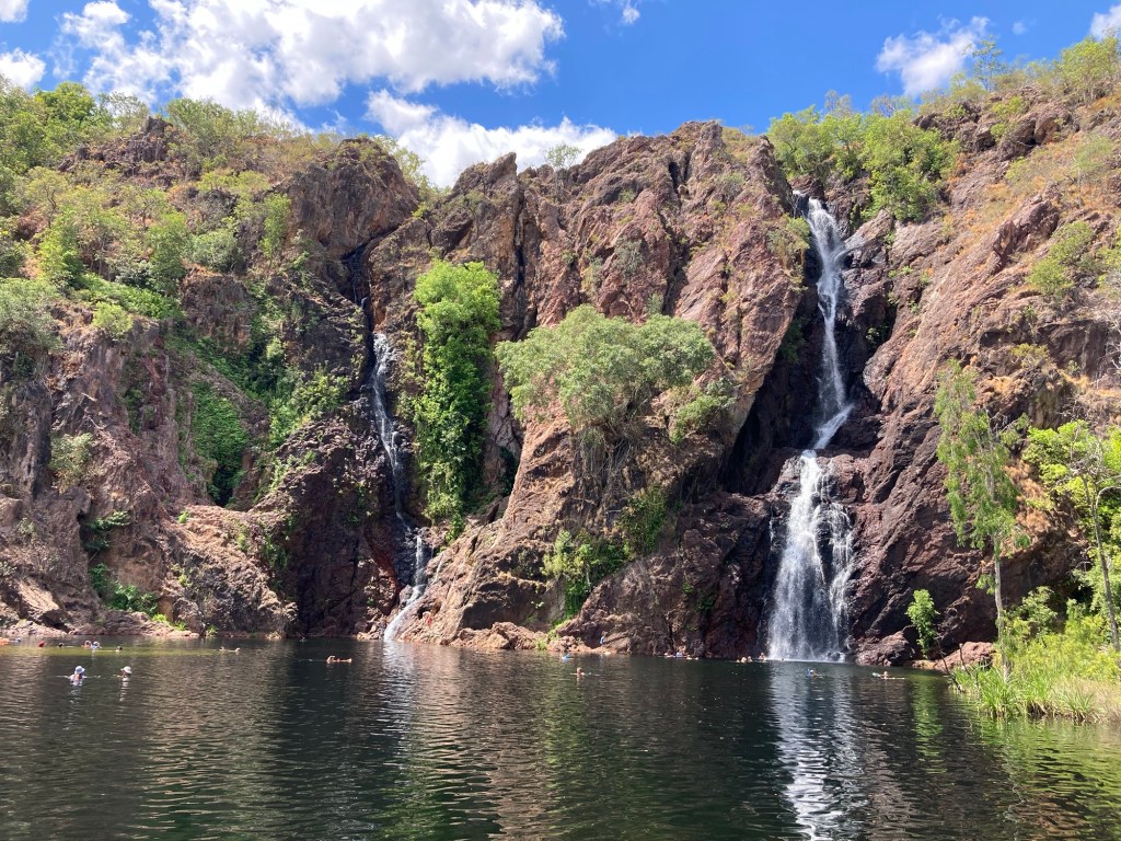
But Jim Jim, the famously high plunge-waterfall is beyond our reach – 60 kms on gravel roads marked 4WD only. I feel like I am missing out on something really important, I say to our guide James, who is clearly wise beyond his years. He says: ‘Ah, you can miss out on Jim Jim for ever. It is just a trickle now – if you get there, it might disappoint. Come back in rainy season and it’s a 200 metre high wall of water. Blows your mind. Then again, the road there might be washed out! But you are enjoying now, yes?’

Let me see: breakfast with the birds at Mamaluka, fishing with crocodiles at high tide at Cahill’s Crossing, two open air galleries of rock art, old, new, undated, by artists named and unknown. And we finish up at Ubirr with sunset on the rocks. Yes, thanks. Enjoying – now!

Sunset at Ubirr, photo credit Co-Pilot

Litchfield National Park, NT: range-perfect for EV tripping

Entering Northern Territory on Highway 1 from WA

Much to our shame, neither I nor Co-Pilot knew of Litchfield National Park until a Territorian EV fellow-traveler saved us from missing out on this glorious region of Northern Territory, which deserves to be on every EV road-tripper’s bucket-list.

Litchfield’s easily accessible and perfectly pristine waterfalls running into Hollywood-film-worthy water holes are a big tourist drawcard. In late August, just past the peak point of tourist traffic in NT, however, crowds are not overwhelming. The view is wildly enticing as you plunge into the crystal clear Wangi waterhole – while secure in the knowledge that your car is parked just a couple of hundred metres away.

Wangi Falls

Litchfield is memorably quirky – you might even say ‘totally bats’! Tolmer Gorge hosts thousands of Orange Horseshoe Bats and just off Wangi Falls, in the monsoon forrest, ‘endangered’ Ghost Bats hang upside down, screeching in the dappled light – perhaps trying to draw attention to the plight of the planet.

Real bats at Litchfield

Even more fascinating are the Litchfield white ants. Our way through northern Western Australia had been lined with termite mounds of various shapes, sizes and colours. But Litchfield is uniquely endowed with these distant cousins of the cockroach, as the ranger informs us, at a talk at the world’s one and only Magnetic Termite Mounds Viewing Platform! Called ‘magnetic termites’ or the ‘Bushman’s compass’, these astounding architects who have been building here for several million years, are still befuddling human scientists by constructing their mounds with a precise north-south orientation!

And if you are more into the arts, you just have to see the magnificent creations of the Cathedral Termites.

A work of figurative sculpture? Or Cathedral Termite mound, Litchfield

Getting There

As Highway 1 runs into Northern Territory from Western Australia (WA stories here), the gestalt change is palpable.

Immediately, the speed limit rises to 130 km/hour having been 110 all the way in WA. The road surface has more visible damage and there is an unfamiliar road sign, which turns out to be a ‘temporary road hazzard’ warning. There are an awful lot of these along the 180 km road from the WA border to Timber Creek – our first stop and first EV charge in Northern Territory.

This pretty red flower is a warning?

There are no fast chargers between Kununurra in WA and Katherine in the NT, a distance of over 500 kms. The stop at Timber Creek Caravan Park is probably the best option for an EV coming in from the West and heading to Litchfield. If you book a room for the night, you can charge your car on a caravan socket, without any additional cost. The compound gates are locked at night, providing a sense of security.

But for an EV we would probably not have stopped at Timber Creek, which turns out to be a particularly charming introduction to NT’s small town accommodation, with its own croc-feeding hour each evening, and a rowdy bar, firmly separated from the dining room for reasons, that become obvious as the evening becomes more ‘spirited’.

The higher speed limit in NT is not welcome from our point of view. Through WA’s Pilbara and Kimberley regions, faced with undependable fast chargers, and trying to make the most of each charge, we have got into the habit of leaving at dawn, driving at a leisurely pace until the volume of traffic increases, making lower than normal speeds untenable.

So, Day 2 in NT, we leave before 6 – a time to meander, enjoying and watching out for the marsupials which are smaller and more plentiful here. With the sun in my eye, even at 80 km an hour, I manage to surprise a couple of large pheasants. It is not till nearly 9 that I see the first truck coming up behind us. But by now, it feels safe to pick up speed, as the marsupials have mostly disappeared back under the foliage and our range anxiety is soothed by the closeness to Katherine where a DC charger, our first in NT, awaits.

I have to confess, it is fun to drive at 130 km/hr (even a tad more when overtaking), but only if you don’t mind running over a small lizard or hitting a tiny bird. Speed kills, even when it does not kill a human.

Accessible

From Katherine onwards, charging is a breeze. There is a fast charger again at Adelaide River, which is only about 50 kms from the entry to Litchfield National Park. So, the 530 kms from Timber Creek to Litchfield is a pretty chilled drive.

Banyan Tree Resort (it used to be called Caravan Park) feels like something out of 1980’s Ubud. If you book a room you can charge your car at a caravan site for $20 a night.

At Banyan Tree Resort, they know what to do with ICE cars

There are several other accommodation options close by, where charging on powered sites should be possible – though like everywhere else some of these places are more accommodating of EVs than others.

Still, I left Litchfield with some regret. We missed seeing the Lost City, which you can only reach with a 4WD. Nor did we have the time to hike the Table Top hiking trail, which takes 5 days, connects the four main water holes in the park, and sounds absolutely divine.

But for all else in Litchfield Park, EVie (our trusty Kona Electric) was the perfect machine. You can enjoy Litchfield National Park in your EV with absolutely no cause for ‘range’/‘charger’/any-other anxiety the popular media currently attributes to EV driving.

Patience is a Virtue when driving in the Top End of W.A

On 28 July Premier Roger Cook reminded us ‘how lucky we are to live in Western Australiaâ€Ļ.’ adding that ‘our EV network was just recognised in Time Magazine’s Top 100 World’s Greatest Places 2024.’

https://www.synergy.net.au/Our-energy/Projects/WA-EV-Network

Indeed if this picture was current reality, with 14 DC charging stations in the 1800 kms between Karatha and Kununarra, the road would have have been sweet indeed for any EV. However, I suspect, that these days even Time Magazine depends on government press releases for its click bait and puff pieces.

Had a real journalist done even the most cursory checking on-line, or even just on the Plugshare app, they would have found that some of the chargers on the map above, have been installed but not yet ‘comssioned’, others have been broken for months, others still, commissioned or not, are whimsical and will work some of the time and not others.

Northern W.A

We left Perth on our lap around Australia aware that the roll out of the WA EV Network in the Pilbara and Kimberley regions was having some difficulty but hopeful that reality could not be running too far behind that fabulous bit of publicity in a world-famous magazine.

We took some precautionary action as well. We wrote to the the man in charge of the WA EV Network project, the Environment Minister, congratulating him on the successful Time Magazine PR and alerting him to some problems with the Network. In particular we noted that the EV charger in Port Hedland was inaccessible due to construction being undertaken by the Port Authority and those at Fitzroy Crossing and Halls Creek, needing urgent repairs, having been vandalised several weeks prior.

As we drove slowly north, the problem loomed larger. We emailed and called pretty much everyone who could possibly have any influence on any charger and probably many who had none!

Briefly the issue is this: between Karatha and Broome, a distance of over 800 kms, there are currently no consistently working DC chargers, even though there are at least three chargers along the way, which have been functional from time to time. Nor is there a dependable fast charger between Derby and Warmun – a distance of over 700 kms – as the one in Halls Creek has been broken for many weeks now and at Fitzroy Crossing things are, well, a tad mysteriousâ€Ļ

Chargefox

Here is what happened. Having failed to get the vandalised charger at Fitzroy Crossing to cooperate, we rang Chargefox, the provider in this instance. But the Chargefox operator could not locate its serial number on her documentation. Nor could she find Fitzroy Crossing on her map!! I offered to send her photographic evidence to prove that there was indeed a place called Fitzroy Crossing in WA, and that it contained all the material signs of a charging station with a Chargefox logo on it. But to no avail.

Fitzroy Crossing: lost by Chargefox?

However, a little after hanging up on the Chargefox lady, our persistence was rewarded. After about half an hour of holding the card this way and plugging the car in that way, with advice from an ‘EV-angelic’ friend, who has driven more miles in his EV than anyone else in Australia, the whimsical charger suddenly roared into life and delivered as fast a charge as our Kona is capable of taking!!

Chargefox continued to be unhelpful. At Kununurra, they did eventually find the relevant charger, but it took a good quarter of an hour to locate the charger, as Chargefox had registered it under a wrong serial number! They were, in any case, unable to help much beyond agreeing that there was indeed a charger where we said it was.

You would think the Kununurra charger would be hard to misplace as it is located right in front of the office of Horizon Power, the WA state-owned company responsible for building the WA EV Network.

The location that turned out to be a boon for us, as were able to walk into Horizon, find Ron-the-Mechanic, who was able to call people who actually knew what they were doing. In a little while someone who might be called Archangel Michael, was able to do some magic from a long way away and bingo, the charger was back in action.

Once we had finished charging, however, Chargefox had no difficulty locating the charger and sending us the bill within 30 seconds! ‘Curiouser and curiouser’ (to quote Alice in Wonderland).

Grateful for the help from Horizon, we were able to make the most of our time in Kununurra, our final stop in WA, taking in the massive Lake Argyle, just 70 kms from the fast charger and the Mirima National Park, which some say is like the Bungle Bungles in miniature.

Pink hills and blue water at Lake Argyle

Like much of the Kimberley, the Bungle Bungles are beyond the reach of a 2WD car. But Mirima, the secret valley, 10 minutes drive from Kununurra town centre, is quite a wonder. For me the rocks in Mirima are reminiscent of the Ellora temples in India, carved out of caves, and dating back to 1000 CE, some centuries before the birth of Greek civilization, but barely the blink of an eye compared to these rock temples belonging to the Miriwoong people, made in the earth’s own time.

Mirima National Park

Yes, Minister

In Broome, on 15 August, after we had badgered the Minister’s office, and called anyone in Horizon who would listen, we got a lovely letter signed by the Minister. He confirmed what we knew: that some chargers had been vandalised and others though built (and some even connected to a power source) were ‘yet to be commissioned’. He was, he concluded ‘very proud of the work his government had done.’ Yes, Minister. But Ministerâ€Ļ

‘Slow is in my blood’

Faulty Fast Chargers should not prevent anyone going to most places where cars can take you at the top end of WA. Anyone road tripping with an EV knows the work-around: slow down! Drop your speed and you can do longer distances per charge. And when faced with undependable fast chargers be prepared to stop overnight at caravan parks to charge up on their powered sites.

Speed, in any case, is nobody’s friend. All along Highway 1 around Western Australia, messed up cars and carcasses remind you to take your time, slow down.

Kimberley, the remote far north of Western Australia, where we have been driving in the last week or so, is one of the most sparsely populated places on earth, with less than 1 person in 1000 sq kms. Even Mongolia has more than twice that density of population!

When you think about how few people live here, the consequent skills shortage, the distances that any equipment has to travel to get here, it is a wonder that we have any specialised, uber-modern technology of speed, at all. Here, on this road, on the edge of a vast wilderness, surrounded by rocks formed by the slow rhythm of geological time, there are so many reasons to go slow!

As Leonard Cohen says ‘I always liked it slow/ Slow is in my blood.’

Exmouth: Electripping the Northern Way to Ningaloo

Sunrise at Vlamingh Head Lighthouse, Exmouth

Many West Australian beaches are ‘world famous’ for their sunsets. But there can’t be too many places in this wide country (4000 kms east to west) where you can see the sun rise and set from exactly the same spot.

Exmouth is a tourist mecca for many reasons. Its population of 3,500 can soar to 20,000 in high season.

About 15 kilometres north of the town centre, the Vlamingh Head lighthouse sits on a tiny 74 metre-high hillock. At sunset, cars are cheek by jowl all the way up and down its curly driveway, jostling for a space to see the sun go down.

Sunset crowd on Vlamingh Head

At dawn, as I silently slip EVie into place, there are just 3 cars, hoping for a cloudless horizon.

At 6:42, the sun peeps out of the strip of ocean, just visble beyond the east coast of the promontory. For a little time, it seems to glide up the horizon, coppery, like a harvest-moon. Then, in a flash, a glowing orb leaps out of the waters east of the pointy beachhead, floods the narrow wedge of land, sends a beam of light into the water across the headland, and dazzles everything in its wake. Sun rise at Ningaloo – pricelessâ€Ļ

Looking back at the lighthouse at dawn

The drive from Karijini to Exmouth went precisely to plan, with three dependable chargers on the way: Tom Price (25 kw), Pardoo (50 kw) and Nanutarra (150 kw). There is a more direct route from Tom Price to Nanutarra, but with a long unsealed stretch, it is a lot slower.

The little town of Exmouth has everything you need to explore Cape Range National Park, including a bank of four fast chargers, convieniently located in the car park at the tourist information centre.

After sunrise, you can slide quietly back down from the lighthouse towards the beach and follow the turn of the only road, heading south, along the line of the Ningaloo reef, into the Cape Range National Park. This is the northernmost section of the Ningaloo World Heritage area.

So much to do along this one road

First stop after day-break, the Observation Bird Hide in Mangrove Bay. To someone whose idea of mangroves are the fearsome Sunderbans in Eastern India, this one looks like a beautiful miniature – almost manicured with a clear lagoon in the middle surrounded by the distinctive mangrove root system. Bird calls fill the morning air. But mostly, the birds are hiding or darting past at the speed of light, and the jumping fish are just silver flashes in the pond.

There is so much to do along the 88 km stretch of road from the charging station in Exmouth to the Yardie Creek Camp site at the southern end of Cape Range Park. There seems to be a beach for every watery activity ever imagined. You don’t need to be brave enough to swim with the whale sharks (I wasn’t), or pay some exorbitant amount for an organised activity further out to sea (but plenty available if that is your pleasure).

You can spend the hours of high tide at Oyster Stacks, snorkling amongst the corals with hundreds of magnificently coloured fish; walk around the Mandu Mandu Gorge trail, then cool off riding the current at Turquoise Bay – and, don’t panic when a huge fish or sting ray floats in on the same current right underneath you! In season, you can see whales breaching from beaches on both sides of the promontory. At Mauritius Beach, at sunset, they might put on a mesmerising show with an ensemble of surfers as corps de ballet – it’s magic if you happen to be there!

When tired, just idle on any beach in the park and marvel at the massive waves crashing on the horizon – breaking against ‘Australia’s largest fringing coral reef’ and â€˜the world’s only large reef located so close to a landmass.’

Yardie Creek Campsite is the furthest from Exmouth fast charger

Cape Range Park provides a perfect opportunity for camping with an EV as you are never further than 88 kms from the WA EV fast charging station in Exmouth. Every one of the 500 wilderness camping sites is booked out 6 months ahead, the day the bookings open! We missed out.

Yardie Creek Road is a smooth and scenic drive: with the ocean flashing in and out of view on one side, and on the other, the gentle rise of the Cape Range (just over 300 metres at its highest), closing in and sliding away. It all seems too accessible.

Yardie Creek Road beteween the ocean and the hills

And then suddenly it is not. The sealed road comes to an abrupt end at the Yardie Creek camp. To get further into the Ningaloo National Park you need wings or sails or at the very least, a 4WD.

Where the river doesn’t reach the sea

A final walk takes you up the Yardie River, which like the road, comes to a stop suddenly, without quite reaching its natural destination, the ocean – it just pools there, its journey suspendedâ€Ļ

Later, talking to some locals I learn that the river only reaches the ocean during rare major flood events. Perhap this is metaphor, a warning, about longings: the river’s for the ocean and mine for the way ahead, which leaves the sealed road, changes to gravel and a few metres ahead, into sand dunes.

End of the road for EVie

But surely, we are not foolish enough to think we can go wherever we want, whenever we want? We know: every vehicle necessarily has its limits, every road some end.

Inside Karijini: a perfect drive through an ancient land

Joffre Gorge at sunset, from the Eco Retreat side

In 2015, a headline in Conde Nast, perhaps the trendiest of travel magazines, said ‘Electric Car Road Trips are the next big thing’. Ten years later, here in outback Western Australia, my fellow grey nomads still look quizical or dismissive, at best curious, when you join a conversation about cars, costs and distances – what else would you talk about on these open roads?

Watching your first sunset with a bunch of other tourists at Joffre Gorge, just 5 minutes walk from your glamping tent, you are just grateful to have this view.

All the way from Cheela Plains I have had a Bangla folk song buzzing in my head:

āĻ—ā§āϰāĻžāĻŽāĻ›āĻžāĻĄāĻŧāĻž āĻ“āχ āϰāĻžāĻ™āĻž āĻŽāĻžāϟāĻŋāϰ āĻĒāĻĨ āφāĻŽāĻžāϰ āĻŽāύ āϭ⧁āϞāĻžāϝāĻŧ āϰ⧇āĨ¤ That red earth path out of the village is making me forget myself, says the refrain.

A dingo welcomes us soon after we turn into Karijini Drive.

If you are driving an EV, you are most likely to enter Karijini from the western side having fully charged up at Tom Price. Your first look out, Mount Sheila, its table-flat top, surrounded by memorial stones, invites a contemplative silence. Makes you appreciate the silence of your car, without an engine that roars or heats up!

Mount Shiela Lookout, soon after you turn into Karijini Drive

If like us, you have booked at Karijini Eco Retreat, back your car into the driveway of your glamping tent and enjoy your expansive back-yard all the way to the horizon.

Our home in Karijini

It is hard not to gush when you talk about Karijini. Even its name is sweet on your tongue, as if belonging to some fairy-tale princess in an exotic land. Use a little imagination (we grown-ups like to call it planning) and just like that fairy tale, Karijini will let you into her magic.

Fully charged up at Tom Price, incidentally at 747 metres elevation, the ‘top town’ in Western Australia, we rolled along 80 kms of beautifully sealed, mostly flat roads, into the National Park, with more than 300 kms still in the tank.

With one exception (Hamersley), the gorges and pools that draw visitors to Karijini are within 50 kilometres of our accommodation. So, there is plenty of range to take in all the main attractions.

You park on the top of the gorges, then walk to the look-out. Or if you are like me, you will want to walk down the marked and graded trails, into the waterways below. ‘Whatever else you do, do NOT miss the Fern Pool’ says a lovely attendant at the Karijini Visitor’s Centre.

Fern Pool, Karijini, not a Hollywood set!

The only problem is, every one of the gorges is mesmerising. Even the carparks provide photo opportunities, like anthills as large as our car and taller than basketball players, and tiny Spinifex Pigeons which won’t stay still for a photo!

Spinifex Pigeon male showing off at the top of Dales Gorge

And then there are the walks, the edgiest down into Weano, which goes from level 4 to level 5 as you scramble and wade and when necessary swim and eventually squeeze between rock walls to the red stone and grey-green waters at the bottom.

Weano Gorge, edgy walk!

You’ve got to be there to know how good that feels!

Final entry to the pool, just wide enough to squeeze through

And before you know it, your three days are gone. And you realise that Hamersley Gorge will take more time and planning.

Having gone to most of the places that any car may go (and beyond where only feet will do) in Karijni National Park, we returned to Tom Price with more than 20 percent still in the battery. With better planning or less time spent taking photos, it might have been possble to get to Hamersley Gorge – the road is partly unsealed but accessible without 4WD in most seasons. But after two full days and three starry nights at Karijini, we are booked into Exmouth, the gateway to yet another famed West Australian National Park.

Sadly, an EV cannot help with time management🙄

Slow Road to Karijini

Sun rise at Eco Retreat Karijini


Karijini, Western Australia’s second largest National Park: the sun is a smudged vermilion marriage mark on the earth’s forehead – my Bengali iconography evokes a bride’s shyly sweet morning after the wedding night before. The sound track is the song of unknown birds. The fragrance on the cold morning breeze is an unfamiliar presence for this urban dweller from the Australian coastal south.

Years of hoping, months of planning, three days and 1600 kilometres of driving has brought us from Fremantle on the south-west coast of Western Australia to the ‘glamping’ spot in the Karijini Eco Retreat.

Read any travel magazine and you would think it is impossible to get here without one of those humungus 4WD diesel-fed vehicles. The travel editor of a WA-based newspaper dismissed my plan of driving to Karijini in at electric car, with his smirk barely hidden behind a curt email ‘Good luck with your EV in outback WA!’

Over a pleasant dinner at the Cheela Plains Station, our last stop before Karijini, I pin down a friendly grey nomad, almost by definition driving a 4WD dragging a motor home. He pays over $250 for every 500 kilometres or so. And that is not including the environmental cost of fumes from thousands of ICE cars in and out of these ancient and fragile landscapes.

Big Cars at the vast Cheela Plains

According to recent government figures 650,000 people visit Karijini each year. It takes a lot of cars to transport all those people!

EVs are not a final solution of course, but with no tailpipe emissions, they are a move in the right direction for pleasure travel.

‘How about it then – a trip around Oz, taking in the national parks?’ I had asked Co-Pilot. He had said ‘why not?’

National Highway 1

I could think of many reasons. I wanted a pleasant trip to beautiful places, not some adventure story of breakdowns and heroic rescues. The Plugshare app showed fast chargers, thin on the ground once you headed north from Perth. The WA government’s planned WA EV network is getting built – but we are not quite there yet.

Also, I was a bit concerned that our two-year-old EVie (a Hyundai Kona Electric 2022, Extended Range) will develop an inferiority complex, sitting between the Big Cars in an over-crowded caravan park, struggling to suck enough electrons from a Caravan socket overnight.

On a good day, with a full tank, EVie has a projected range of 480 kms – but open roads, high speeds and bad weather can easily reduce that by 20%. Yes, Range Anxiety is rearing its ugly head again. What if some of those chargers are broken? ‘We’ll call a friend’, said Co-Pilot.

‘Friends’ refers to â€Ļ ahem, shall we call them EV-angels? Some 30 or so EV drivers have completed the 13,000+ kilometre drive around Australia – some of them more than once. Several live in our neighbourhood in and around Perth and have been generous with their time, advice and encouragment. Our first leg is straightforward: a 450 km drive to Geraldton. And there is a fast charger about half-way at Jurien Bay.

But EVs cannot prevent human errors. 150 kms into the journey, a sinking realisation – my iPad is not with me! The thought of surviving 80 days without my digital companion is unthinkable. We turn back adding an extra 300 km to our day and an extra hour and a half of charging time. Not auspicious.

Definitely the best when you running late and need a charge!

We make Jurien Bay about dinner time: the fast charger is avalable and conveniently located across the carpark from a friendly fish and chip joint! There used to be an Ampol charger at the station across the street – but has been broken for 6 months (Non-functional chargers might turn out to be a bit of a theme – but let’s see.)

Day 2, Geraldton to Carnarvon is smooth. And Overlander Roadhouse, run by a Samoan woman and staffed by a group of awesome Vietnamese Australians, offers unexpectedly good food and a fast WA EV Network charger.

But somewhere along the way an 18-inch crack has appeared on the windscreen.

See the thin blue line?

By the time we reach Carnarvon, the one windscreen repair place in town is closed and remain stubbornly shut the next morning. Though it is reassuring to learn that locals think ‘if you ain’t got a cracked windscreen you ain’t driven in the Pilbara.’

From Carnarvon it is 700 kms to Tom Price where we are booked for the night – it will be less than 2 hours drive into Karijini the follwing morning. We are almost there.

But not quite. The plan was to charge at the newly installed WA EV network charger at Minilya, 140 kms along the way. According to the Plugshare app, it has been working some of the time, even though there is red tape around it clearly asking people to keep out! For us it would not work🙄

Hmmmm???

Co-Pilot tried pleading. I tried abuse. C-P rang the operator. Man at the other end sounded unconvinced by our assertion that anyone had been able to use it. Officially, the charger is ‘not yet active’ – no amount of ‘but we are desperate’ would move him. Next charger: Nanutarra, where we arrived having driven 368 kms on a single charge with just 22 km in the tank and frayed nerves. Neither of us felt like driving another 300 kms to Tom Price.

We stopped for the night at Cheela Plains Station just in time for a magnificent sunset. We got the last room and, yes, they could add us in for dinner.

A perfect place to spend an evening on the way to Karijini, EV or ICE

We are almost there – one sleep, less than 200 kilometres and two perfectly dependable, free chargers provided by Rio Tinto – our next sunset will be at Karijini.

As they say (may be they don’t yet, but soon will): EVs are great for going places. But they won’t compensate for human follies.

To the top of the Worldâ€Ļ

Bourg-Saint-Pierre

The pretty little mountain village, Bourg-St-Pierre is perfect spot for a night’s rest. From here it is just 11.5 kms to the Col du St Bernard, the pass between the two highest mountains of the Alps, Mont Blanc and Monte Rosa. St. Bernard is our final destination on the Via Francigena.

The Alps as you walk towards the Pass

St. Bernard’s Pass is steeped in history and symbolism. All roads might lead to and from Rome. But across the mountain range, paths are few and far between. Some experts say that this pass has been used by people since the Bronze Age, well before the city of Rome was founded, and several millenia before the birth of Christianity.

If, like me, you had been wondering all along the VF whether you were really following Sigeric’s path to Rome, here at a narrow pass at nearly 2,500 metres above sea level, you can be pretty sure that your footfall couldn’t be too far from where Sigeric walked (or perhaps rode a donkey?) 11 centuries ago.

21 June 2023 – dawn had barely broken when we set off for our final day on the Via Francigena. Other than a brief descent to cross the River Dranse, the road sweeps inexorably upwards. I feel as if the thousand kilometres walked in the last two months were just the preparation for this climb, to that mountain pass just ahead: there to marvel at the grandeur of the snow-capped hills, to reach the sanctuary that Bernard of Menthon built circa 1049 as a respite for tired and hungry walkers.

Climbing past pine trees

On paper, the walk to the Pass is not much steeper than the 1000 metres we climbed the previous day to get to Bourg-Saint-Pierre, though our VF app rates today’s walk as ‘challenging’ while yesterday’s was merely ‘moderately’ difficult. And just 5 days ago, a walker reported icy slopes in the final stretch to the top.

But I am bursting with so much anticipation that I hardly feel the ascent as we climb past the pine trees, and beyond the Alpine timberline.

Frolicking Bulls

Then: Difficulty strikesâ€Ļ in the shape of three young bulls. Yes, no bull! I mean yes, definitely bulls. They are standing right on the path, indeed right in front of the stone marked with the Swiss yellow track sign. And there are hundreds of other similar looking creatures as far as the eye can see!

As I am trying to recall what the brave Pandava heroes of the Indian epic did while facing various impediments on their post-retirement final walk up into the heavenly mountains (too long a story to tell, but you can read it here if you are really keen), I notice my courageous companion is silently slinking away.

Hobbit house

To cut a long story short, after discounting many absurd options proposed by you-know-who, I walk back to the tiny cottage we had passed just a few minutes back and knock.

Not Frodo the Hobbit, but Michael the Angel answers the door in the guise of a Swiss German having his morning cuppa. Patiently, he explains that those creatures in the paddock are completely harmless to humans as they are either cows or ‘young bulls, just playing.’

Half hour later, having repeated his assurances in many languages and tones and realising that we are settling in for the night unless he walks us off his property, he sighs, pulls on his boots and proceeds to escort us through the slough of the bovine mire. For the record, even Michael has to pick up a log at one point to discourage the young bulls from getting too playful.

Archangel Michael saves the day – so what’s new?

Apparently the herds of cattle spend a week each year on these lower hills, before setting off for higher pastures. Michael is a font of local knowledge but has a devilish gleam as he bids us ‘bon courage’ (because we clearly need some) adding ‘I have never seen pilgrims frightened by cows.’

Lac des Toules

Past the cow crisis, the intrepid walkers are immediately rewarded with stunning views of Lac des Toules, the mountain lake fed by River Dranse. It gets even more exiting when a pair of Alpine Marmots put in an apperance!

Marmot show

You’d think at this point a walk could not get better. But somehow it does.

Snow-melt streams

In the final three or four kilometres the path leaps over the national highway and tunnel which are now the main thoroughfare from Switzerland to Italy. Heart pounding from the climb, adrenalin coursing through the veins, it is all too breathtaking for words (yes, puns intended).

See the Hospice? We are almost there

We walk skipping through melting snow and then a final tumble across ice and we are at the St. Bernard’s Pass Hospice.

Final stumble

The weather at the Pass turns moody. We had been walking for weeks with spring on our back, facing into summer. But suddenly in the last hour the sky turns grey. The mountain lake, crystal clear when we arrived at two in the afternoon, is blanketed in a milky mist the next morning.

Lake St Bernard

There is something dramatic too about a mountain shelter that has stood open for a thousand years, every day of every year. Though much has changed. The mortuary which once housed the remains of medieval travellers who perished on the icy slopes, has long been closed. The monastery, which Bernard of Menthon established, persists but with only a handful of monks.

Retired

Even the famous St Bernard dogs are now just tourist attractions, as sophisticated search and rescue technology has made them redundant.

Car access to St Bernard’s Pass Auberge

St Bernard’s Hospice is now a hostel and a more up-market Auberge, which continues to house travellers, though these days, unlike Bernard’s times, few are starving and many roll up on wheels, via the sealed road.

Still, compared to most pilgrim destinations, Varanasi, Mecca, Rome, the cool emptiness of the refuge that Bernard created seems an awful lot closer to a haven. But then again, Indians have always imagined that their gods live up on the top of the icy mountains (Himalaya means the land of ice). The kings and queens of the epics always head for the hills at the end of the story. So, perhaps, it is just the stories in my head that make St Bernard’s Pass such a perfect place to end a long journey.

A misty end

The ‘scariest track in all of Via Francigena’?

So where is the track??

The VF track in Switzerland has an awesome reputation as both beautiful and challenging, particularly once it starts climbing into the mountains towards the pass that for millenia has taken travellers into Italy.

Track? What track?

But the tiny 14 kilometres between Martigny and Sembrancher has a more wicked reputation, as the scariest section of the entire 2000 km road from Canterbury to Rome.

Elevation profile Martigny to Sembrancher

Even the elevation profile on the official VF app looks wicked, as if it were giving you the finger! For the record, that finger turned out to be about 125 metres up and 100 down all in the space of less than a kilometre! Imagine climbing on step ladders angled up the face of a 28 storey building and down the other side the same way but the ladders are all rickety and higgledy-piggledy! Get the picture?

Some experienced long-distance walkers will even advise that, if in a hurry, you should opt for a quick and safe train trip into Sembrancher, before continuing the walk further up-hill to Orsieres and beyond. (In my vew it is never good to be in a hurry on a walk.)

View from our window in Martigny

The Swiss Alps do look a bit edgy from most angles, whether it is the serrated peaks in the distance or closer at hand when they rise like something Obelix might have hurled at Roman soldiers. (If you do not know who Obelix is, drop everything and find some Asterix comics)

Taken just off the track near the main road into Sembrancher

So somewhere on a walk that crosses the Alps you would expect something a little edgy, a little sharp – right? On the other hand, WB really does not like heights, so I have been quiet on the matter and he, shall we say, is facing his fears bravely.

Facing one’s fears when it is staring you in the face

Not that you have many options once you have set off on this section.

Most of the track is a narrow escarpment, so slanted that your two feet are almost never on the same plain. The gradient is such that your ankle is always at some weird angle and more often than not, the top-soil moves with your feet. So you slither and slide rather than stride. This is not so much a constructed track as a path yielded by the mountain in response to the footfall of humans (and animals), perhaps over a very long time.

Nothng much between the walker and the river way down below

But just when you think this really is a bit dangerous two young trail runners ‘bonne journee’ past at a speed that would put a mountain goat to shame. Reassuring, really.

There are signs of rock falls, recent and old, all along the way. About 5 kilometres before Sembrancher, we seem to lose the track completely – it simply runs into a pile of rubble and disappears! And all day the VF apps have been undependable as connectivity is minimal in the crags of the hills where we are walking.

WB spots the cairn

Having nowhere else to go, we crawl slowly up the rubble. About 30 metres up, phewâ€ĻWB spots a small cairn – something which walkers around the world read as a trail marker. A hiker (or hikers) ahead left a mark for us to follow. We add a couple of stones to the pile making it a little more visible to those who might come later, then tumble gratefully back onto the trail.

An hour earlier, when the track had (yet again) ducked out of sight and I was shaking my futile fists at the app, a Spanish man came down the hill. He stopped to chat a bit about doing the Camino, and confidently pointed to the correct path. Then overtook me rapidly and disappeared.

Really, track angels seemed to be everywhere, whenever a little help was needed. Where the usual Swiss yellow marker was a bit thin on the ground, someone had thoughtfully scribbled an additional ‘GR145’, the sign we followed all the way through France.

Strategically painted signage

In Bouvernier (a village in between two forest tracks) the bar proprietor insisted on giving us free drinks because she thought we were pilgrims and all my attempts to explain that we were just walkers failed to sway her. Minutes later, we were wondering how to get around a road-block when a young man emerged to provide clear directions in perfect English!

Track angels come in many forms😇

So, does the Martigny-Sembrancher trail deserve its scary reputation? Perhaps it does. But it also takes you through the most beautiful surroundings you can imagine. River Dranse plays hide-and-seek all day – sometimes just a soothing sound, sometimes a visible torrent. Tiny caves and hollows blow cool breath over your legs – like the air-conditioned cool that spills out of big shopping arcades.

Cool cave

Any time the impish trail allows you to take your eyes off your feet, the view near and far is magical, wowing all your senses.

A sudden spray of purple in the green

Perhaps you wouldn’t want to walk this trail in rain and snow, or on a bad-knee day. But we set out on a mild summer dawn. Most of the walk was under a canopy of trees. You don’t feel the danger as the adrenalin carries you along the slippery or rocky or gravelly patches along a path that is a crazy erratic roller-coaster, soaring and and diving, tumbling and rising with a wicked glee.

You are on alert – because you have to be. And all your senses are engaged right here, right now, both because the surroundings are enchanting and, yes, also because walking on the edge of a hill on unstable ground, is just a tiny little bit risky. Enchantment and danger: surely, that is the very definition of a good time😉

Once Upon a River

From Mouthier Haute Pierre to Pontarlier, 23.75 kms. The first six kms of track is closed due to land-slides last year. It is the stretch of path that takes the walker to the source of La Loue river. Our Alpinist host in Mamirolle could not be more emphatic about the ‘must do’ magical nature of just this bit of the road. Closed? How can it be closed?

Ornans on La Loue

The day before, you have met La Loue in her full glory in Ornans. On this sunny day the water is a mirror and the pretty little houses on the river bank can’t stop basking in their own reflected glory. All the eateries sell trout from the river – fish fresh enough to warm any Bengali heart.

A brief and charming walk through tangled woods and manicured parklands along the river gets you to Mouthier Haute Pierre.

Looking down from Mouthier, a tiny village clinging to one side of the natural amphitheatre of the surrounding Jura range, the Loue below is a naughty ripple at the stony pit of the mountains.

In the background the argument with my law-abiding Walking Buddy persists – to take the closed track or not to take it. He has this entirely inconvenient trust in bureaucracies: ‘there must be a reason why the path is still closed’; ‘rules are there to protect us’; etc etc.

Evening in Mouthier, the Track Angel intervenes in the form of a young walker a day ahead. She has just walked through the closed path. Nothing more dangerous here than a few fallen trees, says the angel in her Facebook post. At breakfast next morning another walker says that she is going the closed route. Decision made: we are going to the source of the Loue after all.

Hydro-electric plant information board

Down from Mouthier, past the hydro-electric plant which diverts 10% of the river’s flow to support the needs of the nearby populations, the path curls up past the closure and route diversion signs. And almost immediately it is too beautiful for words – my words that is, but there are always poets you can turn to.

‘I came so far for beauty’

‘I came to far for beauty/ I left so much behind’, sings Leonard Cohen. He was chasing an elusive woman. But it works for the long road (almost 900 kms) we have walked to get here.

‘The sun comes to light on just one side/ I see your face in every direction’

‘Nyamperin matahari dari satu sisi/ Memandang wajahmu dari segenap jurusan’, says Rendra. He was talking about an elusive woman too. But that is just right for the mountains, all around us and impossible to photograph from the narrow foothold taking us up the river to where it all begins, and begins again and again, all the time, constantly, incessantlyâ€Ļthe mouth of a river.

The wonder of life in the heart of stone

‘āĻŦā§āϝāĻ•ā§āϤ āĻšā§‹āĻ• āĻœā§€āĻŦāύ⧇āϰ āϜāϝāĻŧ
āĻŦā§āϝāĻ•ā§āϤ āĻšā§‹āĻ• āϤ⧋āĻŽāĻžāĻŽāĻžāĻā§‡
āĻ…āϏ⧀āĻŽā§‡āϰ āϚāĻŋāϰāĻŦāĻŋāĻ¸ā§āĻŽāϝāĻŧ’ says Tagore. He was writing birthdays, his own in particular. But it works most perfectly at the birth of the river. Where better to ‘hail the victory of lifeâ€Ļthe constant wonder of eternity’?

Afterwards, there are the creature comforts of crepes and coffee at the cafe a few hundred metres up towards a carpark. Then a long climb through the pine forrest on the way to our night’s stop in Pontarlier is pleasant enough. Though it all seems a bit pedestrian after a morning’s exhilarating encounter with a river. Just a morning – gone so soon – but what a morning! You have to be grateful for legs, language and life.

For all the track angels.

There is more to walking than meets the Eye

Ornans, on the bank of River Loue

Having farewelled my Drinking Buddy, Jacques (DB), in the picture-postcard town of Ornas, and having posted nothing (except for the gush over River Loue) for over two weeks, I confess that this is more a retrospective than a current story. We are now well into the Swiss part of VF, looking back on the final and most beautiful section in France, which passes through the two north-eastern departments (Haute-Saone and Doubs) of Franche-Comte, better known as Bourgogne (Burgundy).

Table-mat Map from a pilgrim-friendly B&B in Dampierre-sur-Salon

DB (not to be confused with the non-drinking WB) regards tasting local wines and cheeses a national duty. He believes that right across France ‘young people are acquiring global bad taste from bad American television’ giving up fine local wines and setting off a vicious cycle: closure of village bars and shops, further reducing the attraction of rural living, leading to further falls in rural populations, reduction in demand for bars and so more closures, all in a downward spiral.

Besancon, not small town; but the wine is a fine Bourgogne Chardonnay

It seems the French government shares DB’s concerns and has announced special funding to attract tabacs and bars back to rural areas. In these circumstances, it would have been utterly rude as a pilgrim in this land not to help raise consumption of local produce.

If you are used to Australian distances, France is not a vast country. About 800 kms of hiking has taken us right across its north eastern border – from the ocean in Calais and Wissant, to the Jura Mountains in Bourgogne.

The long shore-line between Calais and Wissant

For a while the dead-flat windy plains with more giant windmills than trees seem unending.

On the way to Therouanne

It’s quite a relief for the leg and the soul to get to the rolling pastures and vineyards of Champagne and finally to the mountains of the Jurassic age in Bourgogne. Closer to the Swiss border the Alps will get higher, craggier. For now the mountain is modest, its peaks comfortably rounded.

Jura mountains in Bourgogne

The architecture of Bourgogne too, has a distinctive feel, with the shiny tiled church spires and the timber framed houses.

In Champagne as in Bourgogne, bars and cafes (when open, that is) seem always to include local wines and cheeses though much to WB’s consternation the ‘salon de the’ often serve no tea at all. In Bourgogne, washed by great river systems created by the Saone and the Doubs pouring in from the Jura mountains, you can dine on local trout. ‘Caught 7 kms down river,’ one proud proprietor tells us.

On the way to Mamirolle

Because we live in a time when visual reproduction is literally child’s play, we tend to capture our experience in pictures. But a long walk engages all your senses.

Almost always you hear the river before you see it. On forest tracks, you hear the birds constantly, though they are visible only rarely and fleetingly. It is your ears that first pick up the buzz of the bee surrendering to a poppy, the first whisper of the breeze on a still morning, and the engine noise to alert you to the tractor approaching on a lonely farm track.

Poppy and Bee

And then there are the things that the adverts about walking holidays and hiking blogs (including this one😊) rarely mention: smell of cow-dung which your nostrils have grown used to before you see a single cow on the paddock! Worse (or perhaps better this way) the unavoidable stench of a dead animal from which you hope to avert your eyes if at all possible.

These flowers remind us of wattles in Australia!

But we are walking in spring and mostly the forests are fragrant with flowers. In Bourgogne, on the first day of summer we walked through our first old growth pine forest. It smells – well, shall we say piney? Part lime, part oil, a bit grassy and just very, very clean.

Pine Forest

And what of touch, you ask? The splatter of mud on your calves is sticky, wet boots wrinkle your feet, stingy grasses irritate the skin as do the ticks, mosquito-bites, the tiny bugs that fly over head and assault your faceâ€Ļ

But then, on a day when the heat has sucked up all your senses and drained your spirits, a sudden up-rush of breeze from the valley splashes your skin with the coolness of the stream you crossed hours ago. Ahâ€Ļ you had almost forgotten there is that lovely river way down in the valley below! In your tiredness you don’t recall its name, but you can still hear its murmur if you stop moving and listen.

Two hours of walking in the sun ahead of you: the cool breeze comes for just a minute and is swamped quickly by the surrounding heat. It feels like a fleeting memory – of the cool dawn earlier today, the spray of the water-fall days ago, and behind concrete memory of real things, the shadowy textures of whatever spells comfort for you.

These long walks, part urban, part historic, part wild, are nothing like a perfect tourist experience – some of it is not even pleasant! But they provide a sensory intensity not captured in pretty pictures. And even words are on shaky ground here!